
Spring Battlefields 2019 Day One: To Ypres
This morning I caught the ferry from Dover bright and early so that I could be in Ypres by lunchtime. I stayed over last night at the Premier Inn near the port, making the journey this morning really easy. On the boat I watched the new(ish) Journey's End film on Netflix. While it is nothing fantastic, it was nonetheless a perfectly watchable war film with some good cinematography.
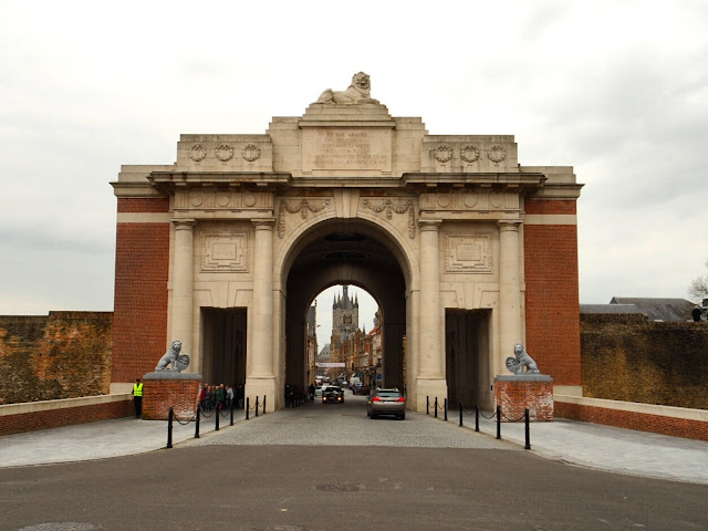
After a quiet channel crossing and an easy hour's drive into Belgium, I had arrived in Ypres in time for lunch before setting off on the first of my walks, heading out east from the city. I was following one of the routes in Paul Reed's Walking Ypres, a book which I highly recommend.
I should, however, caveat this blog write up with the slight confession that upon returning from my walk I put my copy of Walking Ypres on the roof of my car (rookie mistake). After changing my shoes, I drove off without it and upon arriving in Poperinge it was no longer there. I'm not sure how I didn't notice it fall, but unfortunately for me it means I've no longer got the book. It does mean, however, that someone in Ypres can now have a free copy. I hope they use it well!
The walk I followed went out from the Menin Gate to Hellfire Corner and Potijze, keeping behind the British frontline as it was for much of 1915-1917. This was quite an urban walk, even though I passed many fields ,it was distinctly edge-of-town the whole way. Being right by Ypres this is to be expected, but it did mean a lot of traipsing along the side of the road rather than on rural paths.

The first of the route's cemeteries I came to was Menin Road South, a large cemetery which runs along the side of the Menin Road. Buried here is Captain TR Colver-Fergusson, a winner of the Victoria Cross from the Northamptonshire Regiment, who died during the Third Battle of Ypres on 31st July 1917. If I still had my book, I could have told you how this 21 year old officer won the VC. However, I do remember that the line of his epitaph 'no reward can be too great' was taken directly from the medal's citation, reproduced here by no doubt proud parents.

Further along I came to the roundabout that now marks the location of Hellfire Corner, which during the war had been one of the most feared spots in the Ypres Salient. Today, this is only marked with a demarcation stone, a clear indication of how Ypres has been rebuilt as a working city in the century since the war, yet retaining ever-present nods to its losses of 1914-1918.
Turning from here, I switched on my Linesman maps on my iPad and followed my way to Hussars Farm on the road beside what was once St James Trench. At the farm the remains of an observation tower can be seen, but the rest of the buidings have been rebuilt, removing the trace of the old YMCA which had once operated here.

Reaching the end of the road, I came into Potijze and to what had been the site of another YMCA at the chateau. The once grand house was not rebuilt after the war, and in its place, the only things baring the name are the Commonwealth cemeteries. The YMCA would have been somewhere in the fields around here, perhaps in the one today occupied by some very noisy geese!

Just outside of the village is a large French cemetery, a tribute primarily to the French soldiers who served here during the first half of the war, although some also fought here in 1918. Like all French cemeteries, this is a concentration site, with hundreds of concrete crosses naming soldiers who died all across the region. A number are the noticeable headstones of Muslim soldiers, primarily from the colonial, largely Algerian, forces who had fought here at the Second Battle of Ypres and been subject to that devastating first gas attack.

The cemetery also has two memorials within it. The first is a simple obelisk, and the second this dark crucifix, which appears almost like those in tribute to the Germans from its black colour and dramatic depiction.
Turning my back on this, I walked down the road referred to by the British as Oxford Road (Cambridge Road headed off in the opposite direction from the French cemetery). This road is broadly parallel to the British frontline as it was before the Third Battle of Ypres. The map I was using dated from April 1917 and showed the communication trenches that ran off from it, in the direction of the front line approximately 300m to my right as I walked.

What was remarkable walking along here was just how close the city of Ypres feels. The three towers and spires of the Cloth Hall and cathedral are clearly visible downhill to the left, while the front was only just off to my right. This proximity must have felt like a constant pressure on the troops, wanting to protect the city from such close attack.

At the end of this road is the huge memorial to the 50th (Northumbrian) Division. It is yet another Portland Stone obelisk, but it impressive in its size as it stands out in the field. It was clearly visible to me the whole way up Oxford Road.Touchingly, this memorial was designed by a veteran of the division.
Just across the road is Oxford Road Cemetery, a t-shaped cemetery used by troops during the Third Battle of Ypres from the summer of 1917. Soldiers would have been brought back to here through the communication trenches I had just passed by.

I next came to a smaller cemetery further down the road at Wieltje Farm. This is another cemetery used during Third Ypres, including by the 2/4th Glosters. The photos show just how 'stuck out' it looks in an empty field with a busy road running along behind it.

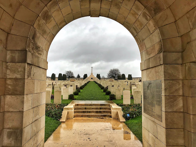
By now, I was heading back in the direction of Ypres, passing back through Potijze. My last cemetery stop was to Ypres Town Cemetery Extension, which sits beside the city's civilian cemetery. I stopped here to visit the grave of Pte Arthur Alexander Hill from Berkeley, Gloucestershire. He had been a pre-war regular soldier with 1st Glosters, enlisting in May 1909, and was killed here during the initial defence of Ypres on 6th November 1914. The military graves here all date from the first year of the war, from during the so-called Race to the Sea which established the broad route of the trench stalemate that was to follow for the next three years. They are closely packed in, with two soldiers' names on each headstone.

Today, the military graves are joined by those of the Commonwealth War Graves Commission themselves, of employees who died in the decades after the war. The row of headstones are all similar, although not identical, to those of the soldiers. With so much talk of the war as 1914-1918, it is easy to forget how much came after. The work of the Imperial War Graves Commission, as it was then, could only really begin after the war when cemeteries were re-arranged, moved and ordered into the rows of white headstones we recognise today.

A photo taken by Sir Arthur Yapp of the YMCA shows the cemetery as it was in 1920 and gives an indication of just how much work the CWGC had to do, not only here but across the British active fronts of the war.

A photo taken by Sir Arthur Yapp of the YMCA shows the cemetery as it was in 1920 and gives an indication of just how much work the CWGC had to do, not only here but across the British active fronts of the war.
My visits complete, I hurried back into Ypres through the Menin Gate to where I had left the car. A note of caution here if you are to follow this walk (which I would highly recommend) and you park in Ypres Grote Markt, the walk is about 3 hours in duration; the same as the car parking limit, so don't lose track!
Back at the car (and with the book forgotten on the roof) I left Ypres to head to Talbot House in Poperinge, where I'll be staying for the next week. I was greeted at the door by Gerry, one of the house's friendly wardens. Gerry had previously been the warden here when I first stayed back in 2014 so it was lovely to be greeted by a familiar face and welcomed back into the Haven from the Trenches.
Kathryn


Welcome to Belgium Kathryn pleasant stay.
ReplyDelete